


Ideas in Waterfront Restoration
When communities were first being settled in the United States, they often sprung up near bodies of water. Of course, the original major cities such as New York, Boston and Baltimore, had access to ocean harbors, where large ports would become important trade centers. Ships could load and unload goods, which could be moved to other locations by land or rivers. As development made its way inland, canals were constructed to move people and goods, and along these canals, tiny communities often grew into larger cities.
There were other reasons to settle near water, aside from the obvious benefits of having a limitless food and water source in your backyard. Land that surrounds rivers and lakes is often found to be particularly fertile, making for excellent agricultural opportunities. And if you were raising animals, a water source was important. But trade and travel—the ability to connect to the rest of the country, and world—was what really spurred growth. The Mississippi, Illinois, Ohio and Missouri Rivers, among others, led to boom towns like Cincinnati, St. Louis and New Orleans.
But by the 20th century, and the prevalence of roads and railroads, water transport and travel became less crucial. Waterfronts in communities often became industrial spaces, and as the decades went on, these industries not only utilized the water, but often used the waterways for disposing harmful chemicals and byproducts. Waterfronts became eyesores and areas that citizens avoided.
Cities and towns are realizing that these amenities are an asset, and urban waterways from coast to coast are once again drawing visitors.
But tougher regulations and shifting mindsets have enabled many bodies of water to detoxify and become viable again. Cities and towns are realizing that these amenities are an asset, and urban waterways from coast to coast are once again drawing visitors. The reasons for communities to enhance and restore their waterfronts are numerous, aside from the aesthetic value, whether it's conservation initiatives or creating recreation opportunities and generating revenue. Or designing and developing waterways for resilience, particularly now with seemingly changing weather patterns and the effects this has on waterfronts and surrounding communities.
"For many years, urban and suburban waterfronts have been neglected, indeed in many places turned away from and considered an unfortunate burden rather than an asset," said Andrew Duggan. Duggan is a principal with Studio Outside, a landscape architectural practice based in Dallas, and has completed many types of projects worldwide, including waterfront restorations. He describes how some communities lost connections with their waterways all together by piping major channels or walling them off behind buildings. "Resurgence in interest in these natural corridors and waterfront edges is envisioning them as points of community gathering, recreation and identity," he added, pointing out the irony of how oftentimes the water was the reason for a settlement at a given location in the first place.
Duggan explained how linear corridors, along a creek, river or lakeshore, create benefit and value on many levels when managed properly, but especially in the realms of natural systems, green infrastructure, recreation and real estate property values. The public's demand for meaningful outdoor experiences has grown, he said, driving an interest in safe, inviting areas for recreation via trails and other park amenities. "Green infrastructure opportunities, however, seek to balance how a restored natural system can do more than a maze of underground pipes, for example, to convey storm events, clean stormwater runoff pollution from urban areas, create wildlife corridors and offer public recreational experiences."
The Forest Preserve District of Cook County, Ill., was looking to develop a camping program across its vast acreage throughout the Chicagoland area, and Duggan's firm was brought on to assist. The planning team completed a series of assessments, including tours of the land holdings, discovery sessions with preserve staff, and identifying opportunity sites. Stakeholders were interviewed, and market studies and public forums were conducted, ensuring that the final plan would serve the needs of the community.
"Several linear camping experiences (canoe camping) were identified along its urban rivers to deliver an accessible natural immersion in the heart of the urban environment," Duggan said.
He added that while public outreach showed the demand was there, it's up to local governments to ensure that such experiences are preserved, so cities can retain a diversity of offerings to residents and tourists alike. "For such offerings to be appealing, however, they must be designed in such a manner that the public investment is protected—thereby requiring a resilient design approach for long-term viability."
Ultimately, Forest Preserve offerings will include day camps, overnight camping and nature study programs.
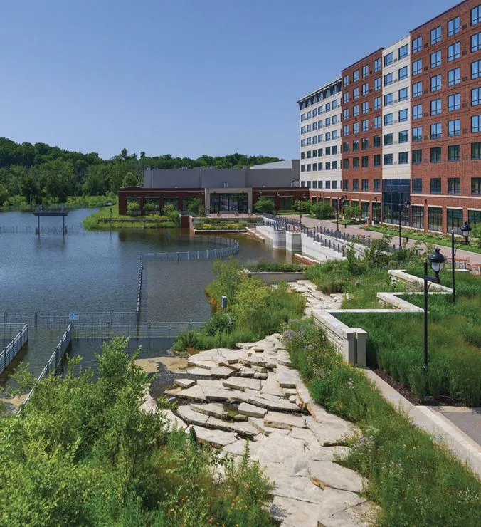
The Grand River is Michigan's longest river, stretching 260 miles. Its history includes being used as a sewer by 19th century loggers and 20th century manufacturers. And while agricultural runoff, urban stormwater and numerous dams still adversely affect the river, it has recovered considerably since the 1960s thanks to community leaders, environmental activists and government officials. The city of Grand Rapids has invested millions of dollars on sewer upgrades, reducing sewage overflows into the river by 99 percent, returning it to a world-class fishery.
And now Grand Rapids is looking to restore a 2.2-mile stretch of the Grand River through downtown. David Marquardt, director of parks and recreation for the city, said they want to restore their namesake rapids as a way to provide for a healthier environment and body of water for greater habitat and species variety, and also for the added recreational benefit.
"It seems many communities are positioning themselves for similar improvements for similar reasons." Marquardt points out that while there are numerous environmental benefits, the economic return on investment is also considerable.
Indeed, Grand Rapids Whitewater, one of the nonprofit organizations working with the city to plan the restoration project, commissioned a study by the Anderson Economic Group that estimated expanded recreational use of the river and riverfront could stimulate net new economic impact of $15.9 million to $19.1 million per year. Water activities that the estimate considered include kayaking, fishing, rafting, stand-up paddle boarding, wading and more. "The rapids project will certainly provide some fun in the water, but the parkland improvements up and down the river corridor will also provide new entertainment and recreation opportunities, all of which are planned to generate additional revenues," Marquardt said.
He added that the city is planning for recreational viewing areas, adventure playground spaces, tree-top board walks, and places to rent kayaks and stand-up paddle boards.
Extensive community engagement in the planning process has been encouraged in Grand Rapids, through meetings, stakeholder interviews, community forums and workshops. Not only does the river flow through the center of downtown, it's linked to a network of tributaries, carrying the benefits of the water system deep into neighborhoods on the city's east and west sides, including underserved areas. Guided by their master plan and other initiatives, the project is currently in the design and permitting stage. Construction is projected to begin in 2019, with the Grand River becoming a water-based trail network of parks, amenities and public gathering spaces.
There are those who feel that dams are dangerous and can contribute to flooding, and that removing them is better for a river's overall health. The Grand River plan includes the removal or lowering of dams, and Marquardt said that one 100-year-old dam will be replaced by an adjustable hydraulic barrier. "This new barrier will be used to control water levels, but also to control the upward migration of invasive fish species from Lake Michigan."
Linear corridors, along a creek, river or lakeshore, create benefit and value on many levels when man-aged properly, but especially in the realms of natural systems, green infrastructure, recreation and real estate property values.
There are many considerations for a community thinking about a waterfront restoration project. Every site has its own unique set of characteristics that must be taken into account. "The river's history, flow rates, flood rates, rock conditions and hydraulic models are considerable and complicated," according to Marquardt. He said Grand Rapids hired a landscape architecture and planning firm from Colorado to assist with river-edge park development and trail connectivity up and down the river corridor, while anticipating put-in and take-out points for river recreation. "The numbers of considerations are really extraordinary and require many talented hands."
With regard to planning and design, Duggan feels that current weather trends must be factored in. "As evidenced by recent history of tropical storm events in various coastal areas, as well as flooding, wild fires and other natural disasters, resiliency of our open spaces should be at the forefront of discussion. Such spaces must anticipate and accommodate these natural events and the potential for them to occur more frequently." He stressed that every aspect of a design should consider how it will react to various conditions and adapt with Mother Nature, rather than simply trying to bolster itself against her.
And, while it's important to consider public input through outreach meetings, Duggan said it's also important to consider "wildlife as stakeholder," especially as urban areas continue to expand. "Bringing natural systems 'to the table' and advocating a voice for them will ensure that a win-win solution can accommodate the needs of the public in a manner that enhances, rather than paves over, the natural environment's function and aesthetic."
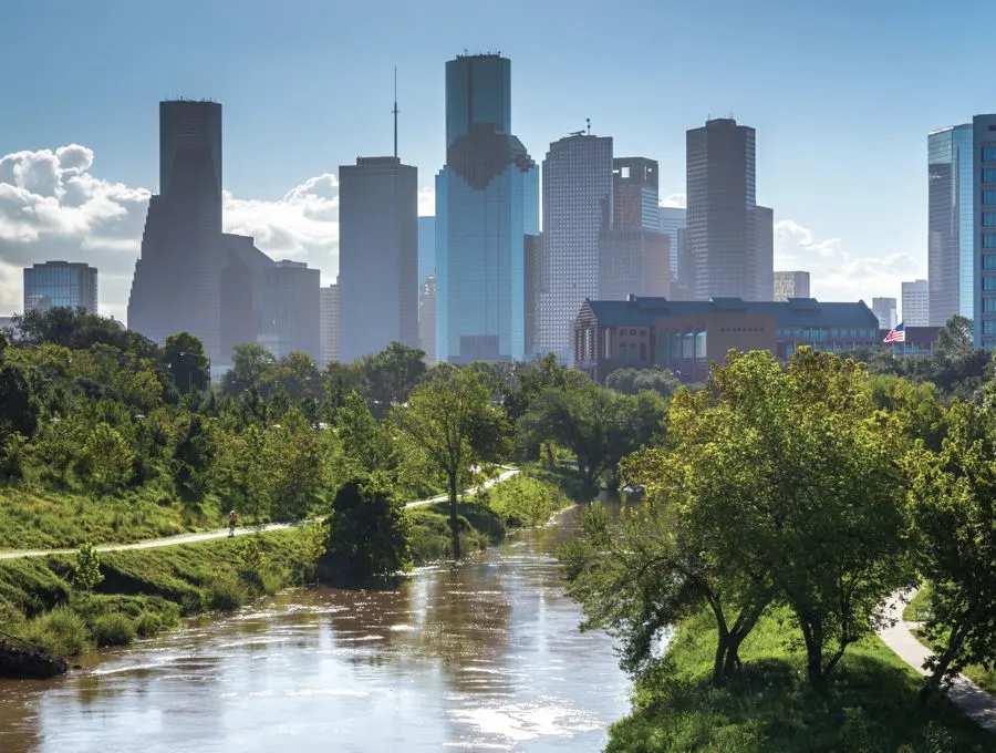
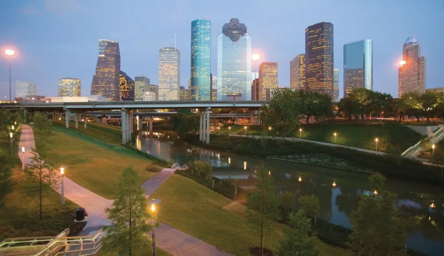
Buffalo Bayou starts just west of Katy, Texas, and flows approximately 53 miles east through the Port of Houston into Galveston Bay and on to the Gulf of Mexico. The bayou has played a critical role in the birth and evolution of Houston. In 1986, Buffalo Bayou Partnership (BBP) was founded, with a focus on enhancing a 10-mile stretch of the bayou in Houston. To date, through the support of corporations, individuals, foundations and government agencies, BBP has raised and leveraged well over $150 million for the redevelopment and stewardship of the waterfront. In 2002, BBP's visionary 20-year Master Plan was issued, with the goal of balancing conservation and development, and creating projects that serve multiple purposes: recreation, flood management and ecosystem restoration.
There are many considerations for a community thinking about a waterfront restoration project. Every site has its own unique set of characteristics.
Anne Olson is president of BBP, working with them since 1995, and she said they're moving forward with all sorts of projects. "We've concentrated mainly just west of downtown Houston, so now we're moving east, right now doing a master planning effort for that stretch of the bayou, all the way to the Port of Houston Turning Basin."
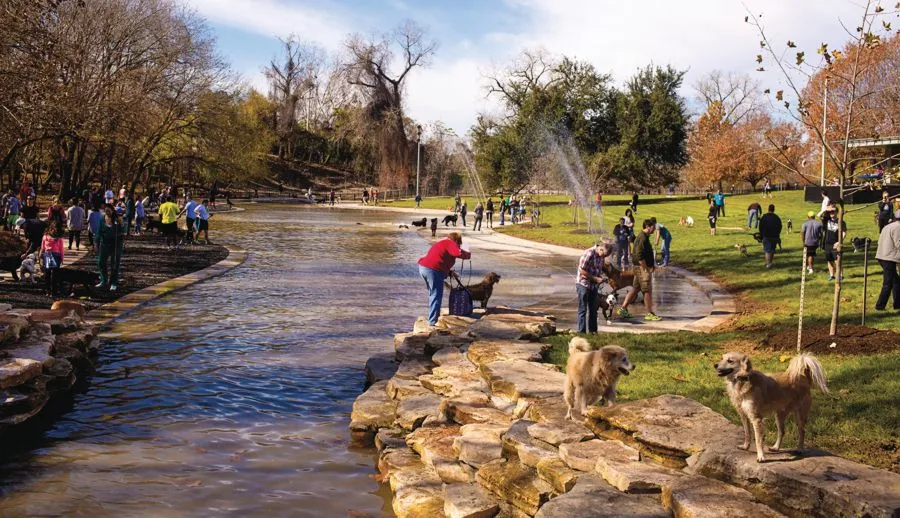
To date, the crown jewel of BBP's efforts has been the opening of Buffalo Bayou Park in late 2015, a 160-acre, 2.3-mile stretch of the bayou featuring hiking and bike trails. New pedestrian bridges have been built, including the 345-foot long Jackson Hill Bridge, which soars 40 feet over the bayou. There are two visitor centers, a sand volleyball court, pavilions and public art. Food trucks are often on-site. Gardens and trail lighting have been added, and BBP has reintroduced native landscaping, including more than 14,000 trees. Bike, canoe, kayak and paddleboat rentals generate revenue, as does a café and various festivals and concerts.
There are parks within Buffalo Bayou Park, including Eleanor Tinsley Park, which has an amphitheater and hosts many large-scale events, including the city's Fourth of July celebration. There's a skatepark, and the two-acre Johnny Steele Dog Park features dog ponds, washing stations, water play features, benches and shade structures. The Water Works, formerly an abandoned four-acre city water system site, will host performances and events. The Cistern, a former drinking water reservoir built in 1926, has been repurposed into a magnificent public space with changing art installations. The Barbara Fish Daniel Nature Play Area has many play features, including a tri-level treehouse/boat deck with climbing net. The Dunlavy is a multi-purpose private event space which also houses The Kitchen, a grab-and-go food counter serving breakfast and lunch.
Olson said that since Buffalo Bayou has always flooded, resiliency has been a guiding principle when considering design. But she added that they were really tested when Hurricane Harvey hit in August 2017. "Lots of erosion and lots of sediment in the park we had recently opened. That was the one site that got it the worst; we spent close to a million dollars just hauling off sediment."
Since Harvey was such a record storm, it's hard to know if work done along the bayou helped minimize damage, according to Olson, but she feels it may have. "All of the parks and trails that we developed have been designed to flood."
Working with the Harris County Flood Control District, designers created a landscape that helps channel runoff and provides greater floodwater conveyance capacity. Park amenities such as signage, stair railings, benches and trash receptacles were constructed with extremely durable materials to withstand the large amounts of debris that flow down the bayou during flooding events.
During Harvey, Buffalo Bayou Park was inundated with water that rose a record 38.7 feet at their Shepard Drive Bridge. The upper portions of the park fared well, but the bottom two-thirds were greatly affected, remaining underwater for weeks as the Army Corps of Engineers released water from two reservoirs. Some areas had significant erosion and bank failures, and trails and footpaths were damaged, along with lighting and some electrical systems. Many trees were downed. The dog park and nature play area remained closed for months, and boat rentals have been curtailed until spring. And while none of the buildings were significantly damaged, BBP did lose a lot of equipment, including mowers, Bobcats, golf carts, a boat and dock and equipment used for cleanup operations.
About 50 miles southeast of Houston, Galveston Island State Park was hardly affected by Harvey, but Hurricane Ike caused almost complete devastation there in 2008. Duggan's firm created a redevelopment master plan which sets a new precedent for coastal recreation planning, by anticipating what of the site will remain in 50 years.
"Every storm is different, but the concepts of anticipating storm surge inundation, salt water intrusion, and wind velocities should be considered on all coastal sites. The biggest consideration facing Galveston is the predicted land loss over the next 50 years, a complex phenomenon that will be affected by overlapping issues of sea level rise, storm event frequency and intensity, and other factors," Duggan said. He added that a successful master plan must predict and plan for the migration of habitat and public use, protecting investments and allowing for natural systems and wildlife to endure rather than simply disappear. Ultimately, after an extensive outreach process involving displaced residents, a multitude of overnight and recreation opportunities was formulated.
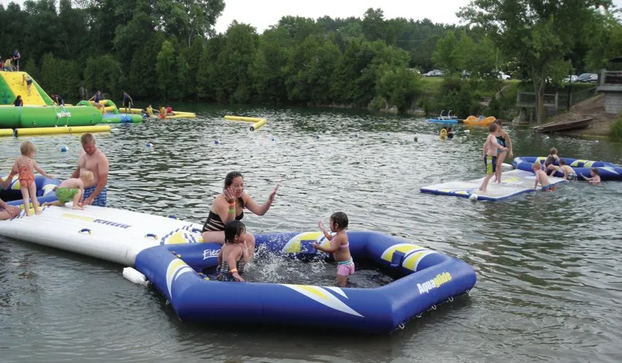
Not all waterfront restoration projects are multi-year, multi-million dollar undertakings. Many communities, resorts, campgrounds and YMCAs have found that enhancing a body of water—whether it's a river, coastal area, lake or pond—can provide many conservation benefits, as well as attract users and generate revenue. Even quarries are being reclaimed as nature areas, sometimes offering sandy beaches, cliff diving, zip lining, wakeboarding, fishing, scuba diving and rock climbing.
The city of Santa Rosa, N.M., was looking for ways to bring in tourists, and they decided to enhance a largely unused public lake, Park Lake, making it a summer playground. They added amenities including a waterslide, diving board, pedalboats and canoes. Their popular inflatable water structure includes monkey bars, rope and "rock" climbing, slides, a raceway obstacle and more. The city now charges admission and vehicle fees, with the park proving a big success with locals and tourists alike.
Back in Houston, they have a strong program built around community service workers, including probationers and even Harris County inmates, who assist with park and on-the-water cleanup efforts. But they also have a robust volunteer program, and after Harvey, more than 1,000 volunteers pitched in to help clean up and restore their Buffalo Bayou Park, according to Olson. This outpouring reinforces the idea that residents are proud of their natural surroundings and amenities, and communities should consider such things as waterfronts and waterways an asset to embrace and preserve.