


From Pokemon GO to Geocaching and Beyond
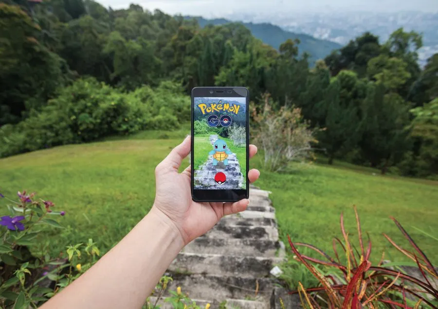
Whether you reside in a city, suburb or rural area, it's likely that at some point last summer you noticed a group of folks milling about in a distracted state, staring at their phones. No, these were not tech-savvy zombies, but likely people who were playing Pokemon Go. The monstrously popular location-based augmented reality game enables players to use their mobile device's GPS capability to locate, capture, battle and train virtual creatures called Pokemon. These creatures appear on the screen as if they were in the same real-world location as the player. Pokemon, Pokestops and Pokegyms—all part of the free-to-play game—can be located, well, virtually anywhere.
This includes parks, forest preserves and nature refuges—places that one might typically consider a technology-free oasis. But in this article, we'll look at how parks agencies are embracing today's tools of technology, adopting an "if you can't beat 'em, join 'em" mentality when it comes to getting people outdoors. And it turns out—in many cases—that nature and technology can exist in harmony.
Go! Play
Sure, some complaints have been lodged against Pokemon Go players concerning trespassing, trampling flora, blocking trails and visiting sites after hours. But by and large, parks and city personnel have reported relatively few problems and have been mostly supportive of the activity. After all, around 58 percent of players are between the ages of 18 and 24, and parks agencies would love to see this elusive demographic visiting their facilities more often. The mobile game app has been downloaded more than 500 million times worldwide, and if some of these users visit a park to find Squirtles and Charmanders but are also taken by the song of a cardinal, the smell of wildflowers or the feel of the sun on their face, then all the better.
Often, Pokestops—where players can collect virtual items useful in the game—are located at historical sites, landmarks and monuments. The Great Smoky Mountain's Mountain Farm Museum hosts three Pokestops, and when located, historical text pops up on the screen and players can tap an icon to learn more if they should choose. Many other state and national parks have gotten on board as well, though tree canopies and mountains can certainly hinder cell reception and Wi-Fi. But some visitor's centers, which have Wi-Fi, double as Pokestops or Pokegyms, which are places where players can battle each other and level up.
Many local parks agencies have gone the extra mile to encourage players to visit. In Johnson City, Tenn., parks officials held a three-day event where Pokemon Go players could ride a transit bus to three city parks to hunt for Pokemon. The rides were free, and portable battery chargers were provided, plus lures were placed at various Pokestops. Lures can be purchased for under a dollar to place at a site, lasting for 30 minutes and enhancing a player's chance of catching coveted Pokemon by attracting them to a fixed location.
In Arkansas, the North Little Rock Parks Department created and posted maps of all the Pokestops and Pokegyms in their parks. In Oklahoma, Tulsa hosted a Pokemon Go 5K Run. Parks personnel in Nashville, Tenn., organized Poke walks. In New York City, there was a Pokemon Go safari—a two-hour tour of the hottest Pokemon sites in 843-acre Central Park. A co-guide on the tour was well-versed in the history of the park, and explained historic areas and landmarks during the tour, which ended at the Museum of Natural History. And some parks extended their hours on certain days well into the night, with some even bringing in food trucks or providing free charging stations.

In Arlington, Texas, children and adults alike were flocking to parks to catch Pokemon, so the Parks and Recreation Department compiled a list of the best parks to visit Pokestops to stock up on game items or battle it out in Pokegyms. The list not only detailed where the hottest Pokemon activity might be happening and tips on playing the game, but also contained information on the parks themselves, in hopes that players would want to discover new places to enjoy, with or without technology.
Phillip Rogers, who works for the Arlington Parks and Rec Department, said they were fortunate to have early Pokemon adopters on their staff. "Once we realized the potential viral aspect of the Pokemon craze, and the outdoor nature of the game itself, it was a natural fit for our department."
He said they had a tremendous response to their "Parkemon" campaign, purposely promoting some of the larger parks to combat any issues of overcrowding, while also highlighting recently installed park features such as their Sculpture Trail at Richard Greene Linear Park, which features numerous sculptures along the walking path from various national artists.
"With many players being first-time visitors to our facilities," he said, "there was an accommodation and educational process that had to take place both with our staff and our customers." For instance, many players were walking onto a golf course during play, so they created signage for certain locations, asking players to check-in with the front desk. They also advertised food and beverage discounts at Tierra Verde Golf Club for Pokemon Go fans through a hashtag social media campaign. "We didn't see any increase in damage or complaints associated with increased traffic from Pokemon Go," Rogers added.
Go! Geocaching
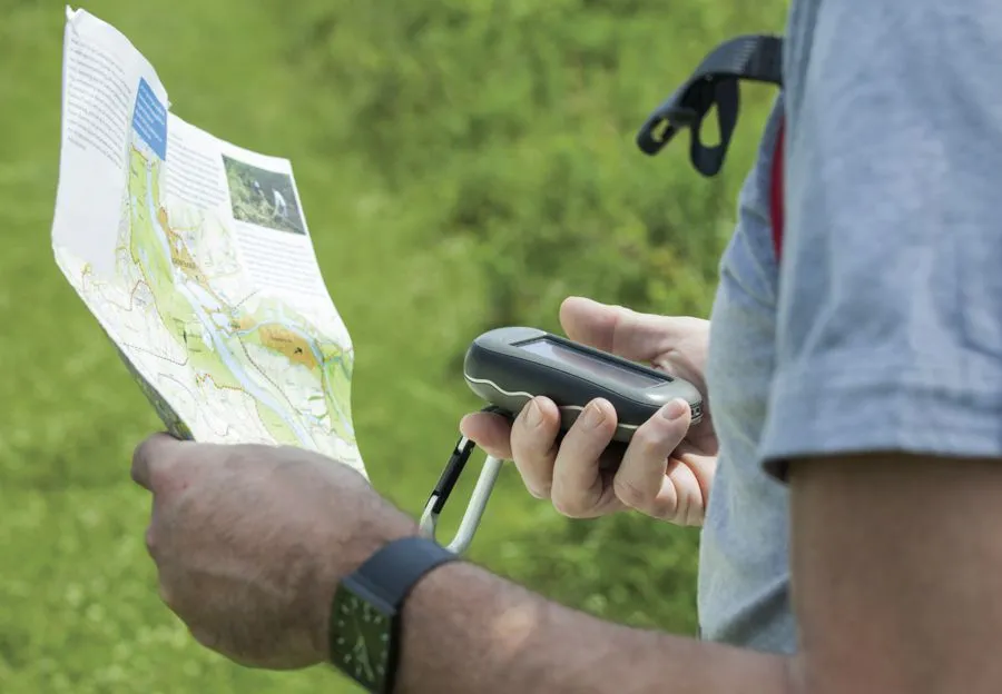
Another extremely popular activity involving geo-location is geocaching, in which participants use a GPS receiver or mobile device with a GPS app to find geocaches at specific locations marked by coordinates that they've downloaded. Geocaching combines the high-tech feel of online games with getting outdoors and treasure hunting. It's estimated that more than 2 million geocaches exist worldwide. A typical cache is a waterproof container which holds, first and foremost, a logbook containing information from the cache's founder and notes from the cache's visitors. The visitor should sign and date the logbook—which might contain information on local attractions, coordinates to other caches, anecdotes or other messages—then place it back exactly where it was found. They also record their exploits online, typically at geocaching.com.
The cache also might hold treasures or prizes, which could be small toys, coins or currency, ornamental buttons, CDs, books, maps, software, jewelry, tickets, tools or games. Players may take objects in exchange for leaving something of similar value. Disposable cameras are popular as they allow visitors to take a picture, to be eventually uploaded to a geocaching website. Also common are objects to be moved from cache to cache—called hitchhikers, Geocoins, Travelbugs or Pathtags—whose travels may be logged and followed online. These trackable caches are sometimes assigned specific goals, such as being placed in a specific geocache far away, or traveling faster and farther than other hitchhikers in a race. Each cache has a terrain and difficulty rating of one to five stars, with one star meaning the cache can be found quickly, and five stars meaning the cache is hard to find or open. They can be located under a tree stump, on the side of a rocky cliff, underwater or in cities both above and below ground, inside or outside of buildings.
Geocaching has proved to be a compelling way to get folks outdoors and explore places they wouldn't normally have visited. And the Pokemon craze caused more people than ever to sign up for geocaching, since media outlets often used it as a reference point when describing Pokemon Go. Therefore many local and state parks have embraced geocaching, while also stressing that participants need to be respectful of flora, fauna and park rules. Rogers said they have a very active geocaching community in and around Arlington. "Recently, we've partnered with these groups in hosting a Cache-In-Trash-Out day at Lake Arlington, where the groups collected trash and debris around the lake while also collecting caches. It's a win-win for all involved."
Geocaching is one of the most popular activities in Georgia State Parks, with more than 60 parks and historic sites containing hidden caches. "We've introduced state parks to a whole new group of people, from longtime enthusiasts to people just learning how to geocache," said Kim Hatcher, who works for the Georgia Department of Natural Resources (DNR), adding that they couldn't have started the program and had such success without the volunteers who help place and maintain the caches.
The Georgia DNR built on this enthusiasm by introducing various Geo-Adventures, including the History Trail GeoChallenge, where players had to visit 14 historic sites, answer questions related to each site, and solve a padlock code to open the 14 caches, where prizes awaited. And to celebrate their 85th anniversary, Georgia State Parks sponsored the Birthday Bash Geocache, which involved not only finding limited-edition trackable Geocoins, but also spending at least one night in a State Park campsite, yurt or cabin, or attending a Georgia Geo-Camper event in 2016.
Go! Social
Hatcher said that Facebook is a great tool for sharing information and feedback between visitors and park staff, with many state parks having their own Facebook pages to post events and photos, which are also shared on the main Facebook page for the Georgia State Parks division. "Instagram is a valuable tool as well because it allows us to introduce visitors to beautiful new locations, especially lesser-known state parks. It's amazing how many people react to a gorgeous photograph," Hatcher said, adding that they're also able to showcase new facilities such as cottage renovations or large group shelters.
Rogers said they also maintain an active presence on social media including Twitter, Facebook, Instagram and YouTube, with more than 9 million impressions between Twitter and Facebook last year alone. "The key is crafting a unique message for each platform, as our demographic/psychographic profiles of our users differ dramatically between them. We've also started using Snapchat, and the Geofilters, for our special events."
Facebook is a great tool for sharing information and feedback between visitors and park staff.
Rogers also explained how a sizeable portion of their marketing budget is allocated on social media advertising as opposed to traditional advertising methods, to better tailor their advertising to certain demographics or geographical areas.
Paul Holtan works for the Wisconsin DNR, and said their Facebook page has more than 80,000 followers. They also have Twitter, YouTube, Pinterest, LinkedIn, and Flickr accounts. He described successes they've had with their Facebook campaigns, including a "Hidden Treasures" contest, which was run in a sort of "March Madness" format. "We selected 16 of our lesser-known, lesser-visited parks and put them into brackets and allowed people to vote for their favorite park in each bracket. We moved up the brackets each week, just as a basketball tournament bracket would work," he explained. The contest was highly successful, bringing attention to parks that people were not as aware of. Almost 24,000 votes were cast.
They also held the "Twelve Gem Challenge," asking people to submit selfies taken at designated sites within 12 park properties. An online storyboard was created, and participants could upload the selfies to a photo album on the TravelWisconsin.com website. Another success was the "Fall in Love with Wisconsin State Parks" contest, where people were invited to send in photos of their favorite fall colors at park properties, with almost 4,500 votes being cast for favorites.
Go! Techie
QR (Quick Response) codes—those ubiquitous black and white barcodes—are another inexpensive way that parks have been marrying technology and nature. These appeal particularly to younger people who are seemingly tethered to their smartphones. The codes can be placed on stickers and affixed to trees, posts, geologic features, kiosks or added to visitor brochures, printed maps or signs. Parks and refuges often place them at trailheads, where visitors can use their phones to link to online maps and trail guides, historical and nature information, video and audio clips.
The J.N. "Ding" Darling National Wildlife Refuge on Sanibel Island in Florida developed the iNature Trail, which features two sets of codes. One set—targeting kids—has specially created interactive YouTube video links. The other is geared toward adults and has more informational video links.
Everyday there are new mobile apps entering the market, and nature apps are no different. Many are free or under $10, including MyRefuge, which provides information on hundreds of National Wildlife Refuges, such as the best locations for birdwatching, hiking and wildlife viewing. TreeBook, Florafolio and Leafsnap allow users to identify trees, shrubs, perennials, ferns, vines and grasses. Bird enthusiasts will like WildLab Bird, National Geographic Birds and iBird Plus, which feature information on hundreds of species, along with bird call recordings, drawings, maps and photos. MyNature Animal Tracks assists in identifying animal tracks while Project Noah lets users upload their own wildlife photos or review those uploaded by others, while also documenting our planet's biodiversity.
New technologies also continue to evolve at recreational and sports facilities. Sports turf managers can monitor and measure soil temperature and moisture, sunlight and leaf wetness instantaneously.
Some challenge courses (modern versions of obstacle courses) have an app allowing players to compare their times with their friends or with users across the country, with real-time results and leader boards, since the courses are designed to the same specifications. The app also allows schools and parks to better gauge how the course is used, since it gathers anonymous data including age and gender of participants, frequency of use, number of visits and more.
At aquatic facilities, wave generators and surf simulators create waves every several seconds that dramatically change shape, size and difficulty level at the tap of a screen. If you're into slideboarding, a video game-integrated waterslide where participants use a boogie board and attempt to hit targets while sliding, a progressive system will track your score—allowing you to compete against yourself or slideboarders at other facilities. As with the Challenge Course app, these features tend to spur repeat customers who like to compete and improve their scores.
Back in Arlington, Texas, Rogers reflects on how technology can further a park's mission: "Technology provides us the opportunity to make data-driven decisions that ensure we are fulfilling our mission of providing quality facilities and services that are responsive to a diverse community, and sustained with a focus on partnerships, innovation and environmental leadership. Whether it's embracing apps such as Pokemon Go or utilizing software/hardware solutions that provide operational efficiencies, streamline workflow and provide potential cost savings, we are always on the lookout for technological solutions that will benefit our department and constituents."
Of course, there are always two sides to a coin. At the Blandford Nature Center in Grand Rapids, Mich., they scrapped their QR code program after receiving feedback that they shouldn't encourage people to stare at their phones. And, while they do use social media as a primary marketing tool, maintaining around 11,000 followers on Facebook, they use the platform to entice people to get off the computer, according to President and CEO Jason Meyer. "We use digital platforms to encourage participation, sans electronics, at our nature center. There's just no substitute for experiencing nature first hand. We don't discourage use, but we don't encourage it either."